Australia's National Climate Risk Assessment 2025: What Every Property Owner Needs to Know
The Australian Climate Service's 2025 assessment identifies 63 nationally significant climate risks and 11 priority threats reshaping Australia's property landscape. Here's what property owners and buyers need to know about floods, bushfires, heat, and sea level rise.

A Landmark Moment for Climate Transparency
In 2025, the Australian Climate Service (ACS) delivered the most comprehensive national climate risk assessment in the country’s history. The report maps 63 nationally significant climate risks across every major system that underpins Australian life — from healthcare and infrastructure to the economy and natural environment.
For property owners and prospective buyers, this assessment isn’t an abstract policy document. It’s a data-backed warning that the climate risks affecting property values, insurance costs, and liveability are accelerating faster than most Australians realise.

63 Risks Across Seven National Systems
The ACS identified risks spanning seven interconnected systems:
- Communities — displacement from floods and bushfires, mental health impacts from repeated disaster events
- Economy — reduced agricultural output, tourism disruption, rising disaster recovery costs
- Health — heat-related illness and mortality, vector-borne disease expansion, air quality degradation from bushfire smoke
- Infrastructure — road and rail damage from flooding, power grid stress during heatwaves, stormwater system failure
- Natural Environment — coral reef decline, biodiversity loss, ecosystem collapse in fire-prone regions
- Primary Industries — crop yield reductions, livestock heat stress, fisheries disruption
- Defence — operational constraints, base vulnerability, humanitarian response demand

Of these 63 risks, 11 were classified as priority risks demanding immediate national attention. Seven additional risks specific to Aboriginal and Torres Strait Islander peoples were formally recognised for the first time.
The 11 Priority Risks That Reshape Property
The priority risks with direct property implications include:
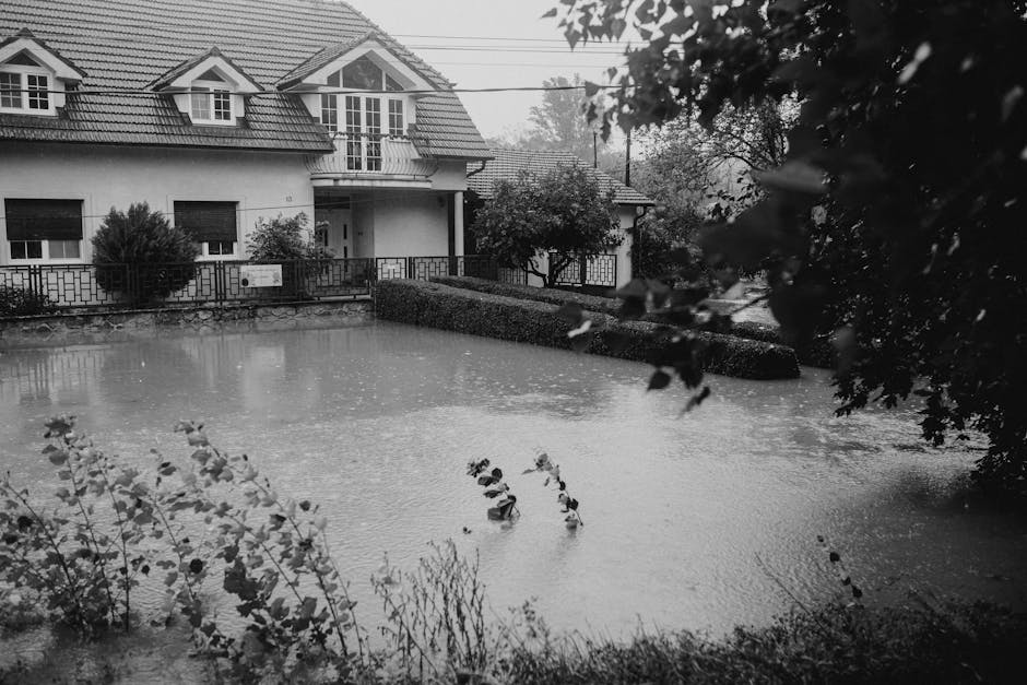
- Riverine and coastal flooding — affecting an estimated 1 in 6 Australian properties
- Bushfire — fire weather seasons extending by 2–4 weeks across southeastern Australia
- Extreme heat — heatwave days projected to increase 20–50% across southern capitals by 2050
- Sea level rise — 0.3–0.6 metre projections along the eastern seaboard by 2070
- Severe storms — rainfall intensity increasing 10–30% in flood-prone catchments
These hazards don’t strike in isolation. The assessment emphasises cascading and compounding impacts — a severe bushfire season strips vegetation, which increases erosion, which amplifies flood risk in the following wet season. A single property can face escalating multi-hazard exposure over time.
What This Means for Property Values

Research from PropTrack and the Climate Council has already shown that flood risk alone has wiped $42.2 billion from Australian residential property values. The ACS assessment suggests this is just the beginning.
Properties in high-risk zones are experiencing:
- Persistent value discounts of 5–15% compared to equivalent low-risk properties
- Insurance premium increases of 30–80% over the past three years in exposed postcodes
- Slower capital growth — high-risk areas underperform low-risk areas by 1–3% annually
- Emerging “uninsurability” in parts of northern Queensland, the Northern Rivers, and peri-urban bushfire zones

State-by-State Exposure
New South Wales
The Hawkesbury-Nepean floodplain, Northern Rivers, and Blue Mountains bushfire corridor face the highest combined risk. Western Sydney is also increasingly exposed to urban heat island effects.
Queensland
Coastal communities from Cairns to the Gold Coast face compounding cyclone, flood, and storm surge risk. Inland regions face drought and extreme heat stress.
Victoria
Gippsland and the Dandenong Ranges have elevated bushfire risk, while the Maribyrnong and Yarra catchments face repeat flood exposure. Melbourne itself is projected to experience significantly more days above 40°C.
South Australia
The Murray River corridor, Adelaide Hills bushfire zone, and Gulf St Vincent coastline are flagged for escalating risk through 2050.
Western Australia
Perth’s northern suburbs face coastal erosion, while the Kimberley and Pilbara experience intensifying cyclone patterns and extreme heat.
Building Standards Are Changing
The National Construction Code is being progressively updated to reflect new climate projections. This means:
- New builds in bushfire-prone areas require higher BAL (Bushfire Attack Level) ratings, adding $20,000–$80,000+ to construction costs
- Flood-prone areas may require raised floor levels, affecting design and cost
- Energy efficiency requirements are tightening, with NatHERS ratings becoming more important for resale value
Disclosure Requirements Are Evolving
There is growing regulatory momentum toward mandatory climate risk disclosure in property transactions. Several states are reviewing legislation that would require vendors to disclose known climate hazards — similar to existing requirements for asbestos, flooding history, and contamination.
Buyers who don’t assess climate risk before purchase may find themselves holding assets that decline in value as disclosure norms tighten and risk repricing accelerates.
How to Protect Your Property Investment
The ACS assessment makes one thing clear: understanding your property’s specific climate risk profile is essential due diligence, not optional research.
ClimateNest analyses over 20 climate and environmental data sources — including BOM weather stations, CSIRO climate projections, ABS demographic indicators, DEA coastline data, and local council flood mapping — to deliver AI-powered risk assessments for any Australian address.
Whether you’re buying your first home, expanding a portfolio, or advising clients as a conveyancer or buyer’s agent, a ClimateNest report gives you the climate intelligence the market increasingly demands.